Long Point
Latitude: 42°34'0" N
Longitude: 80°3'0" W
Site Elevation: 175 meters above sea level
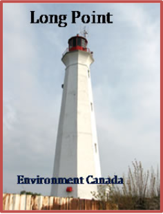
Long point is a sand spit that extends about forty kilometers into Lake Erie. Presenting a dangerous obstacle for mariners, in 1928 the U.S. urged the British to erect a lighthouse or allow the U.S. to do so. The first lighthouse was built by the British in 1830 but only lasted eight years before waves undermined the foundation and the lighthouse was taken down. A second tower was built in 1843 near the tip of Long Point. The present concrete lighthouse was completed in 1916 1,700 feet southeast of the second tower.
Led by Dr. Chris Spence of Environment and Climate Change Canada an eddy covariance station was placed atop of the Long Point lighthouse in 2012. The eddy covariance station along with other ancillary meteorological instrumentation are 32 meters above lake level. Real time conditions at the Long Point lighthouse can be viewed at http://weather.gc.ca/marine/forecast_e.html?mapID=11&siteID=07503