Great Lake: Huron County: Chippewa
Latitude: 45.97061668 Longitude: -83.85621708
![]() Download Photo
Download Photo
![]() Download Maplink
Download Maplink

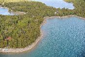
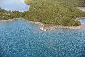
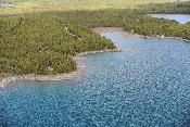
The Great Lakes Shoreviewer provides professional color photography of every inch of coastline (and many islands) in the Upper Peninsula of Michigan (Lake Superior, Lake Michigan and Lake Huron). Each coastline photo also has a series of maps showing important natural features for planning and protection efforts. To start, simply click on the locator map to view photos.
Note: Scroll Back and Forth With Arrows
Downloadable Planning Maps
These maps are specific to the photo being viewed and include; soils, wetlands, critical dunes, topography, color infrared photography and true color vertical photography. Just click the map link under the photo you want to see the map for.


45.97020002,-83.85520041
45.97061668,-83.85621708
45.97111668,-83.85846708
2 Peter White Drive, Presque Isle Park
Marquette, Michigan 49855
906-228-6095 or by fax at 906-228-6863
Graphics provided by Elegant Seagulls, Code Development by Web Maestro, Inc.